
The Faultless Shot 1968
My Story – I was there. In 1965, I took a job in Radiation Safety with Eberline Instrument Co. out of Santa Fe, NM. We were first sent to the Nevada Test Site in Mercury, NV North of Las Vegas. Yes, that’s where Area 51 is and the same place our government set off atmospheric nuclear bombs in the forties and fifties.
I have many stories to tell from the months I spent there but this is the scariest. Certainly one I would not like to relive. Last week while combing the Internet, I searched “Faultless”, the name of the shot, that’s what they call it when they set off a device.
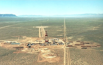
 It was 1966, when I first worked on Faultless and I lived with my new wife in Tonopah, NV about 90 miles east in the “Central Nevada Test Area”, in Hot Creek Valley, 10 miles from Warm Springs, NV.
I was amazed to find a video and loads of information I had previously not been privy to. For instance, that it was a one megaton device set off 2,460 feet underground. I was onsite the day they lowered it into the hole and the day they set it off. However, this is an untold story of ‘The Incident’, what AEC calls an accident and it happened on my watch.
 Faultless was part of the Plow Share Program, Peaceful Uses of Atomic Energy. Eberline Instrument Company was contracted by the AEC to perform Radiation Safety.
The Incident
My crew was on site one night when core samples were being taking. It was months after the shot was fired. We were in full anti C’s. That’s overalls taped at every opening and around the edges of boots and gloves, with full-face respirators, rubber boots, and lead lined aprons and gloves. Around midnight, the sand line (a cable that when weighted would drop down the center of the drill pipe) was pulling up the core shoe.
Core shoe is a heavy cylinder tapered at one end, about 16 inches long, connected to the sand line. This was then dropped to the depth set by the HP’s (Health Physicist) where it kicked out the side of the drill pipe puncturing the ground to take a sample. We were constantly reading our instruments and recording radiation levels.
The drill crew, all off the deck, except for the Mud Cat (head driller) who was running the reel that would raise and lower the sand line. It was dropped very fast to create as much force as it could to puncture the ground. A very dangerous procedure as it could easily catch, then backlash, spill cable all over the drill deck, then free up again and run at a high speed snapping up the cable, running so fast it could easily wrap around a man’s leg and rip it off. The retrieve, however, was a very slow process.
Once the shoe was up, two of my crew would grab the core shoe with tongs and the driller would wrench it from the sand line. We would then carefully carry it to a bench with a press set up at the opening of a 14 inch lead pig, place it on the press, press it into a plastic tube, cap both ends, and push it into the pig, seal the pig and move it aside for its trip to Lawrence Radiation Laboratory (LRL).
By the second retrieval, around 3:30 am, we were tired and weary. Dennis, just up from a nap, dropped his tongs and the other end jerked out of Chet’s hands. The core shoe slammed on the drill deck scattering material all over. The Mud Cat jumped off the deck to his truck and pealed out across the desert with his crew close behind.
Our meters pegged as we clicked up through two settings before we dropped them in a panic. Clumsily, we scraped up as much of the sample as we could, shoving it into the tube for placement in the pig. Then washed the floor and each other off, to the satisfaction of our meters, into the mud pit with the rig’s pressure hose.
 Once satisfied that there were no more obvious meter spikes, we created a decontamination line as taught. Dropping all of our clothes and gear on the hot side, we ended up on the other side in our underwear. Then we ran to the truck and called the boss on the radio who went crazy and told us the get the $%#^ out of there.

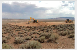
The site was shut down and roped off. It stayed that way for months until the mud pit evaporated. Heavy equipment was brought in to remove the mud leaving the pit lined with tar paper used in roofing. My crew was, in an act of punishment I guess, sent back to the mud pit in August to remove it.
Imagine, five guys in hundred-degree temperatures, in full anti C’s just like before. However, this time using hand hatchets to cut the tar paper into to pieces that would stack flat into 55 gallon drums. That was HELL! It took us 3 weeks of 10 hour days, living in Tonopah, commuting to the site, to complete the task.
No I didn’t quit, I needed a job.
Here is a Video from GZ (ground zero) when the shot was fired.
from the web at http://www.rachel-nevada.com/places/faultless.html
In the 1950’s, when not much was known about the effects of nuclear explosions, many nuclear tests were conducted at the Nevada Test Site north of Las Vegas. The tests were conducted both above and below ground, in the beginning with little or no safety precautions. When it became obvious that the underground nuclear tests in the Nevada Test Site were a serious safety risk for nearby Las Vegas, the Atomic Energy Commission (“AEC”, today known as Department of Energy “DOE”) decided to conduct the most powerful tests in even more remote areas.
One of a total of 10 such locations was the “Central Nevada Test Area”, in Hot Creek Valley. It is located on public land, about 70 miles northwest of Rachel.
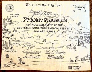
A series of underground thermonuclear tests was planned, more powerful than any of the tests before. Project Faultless was the first calibration test, intended to determine the geological impact. It had a yield of approximately 1.0 megatons, about 67 times the energy of the bomb that was dropped on Hiroshima, Japan! Other, even more powerful tests were to follow later.
Project Faultless was detonated 3,200 feet underground on January 19, 1968 at 10:15am.
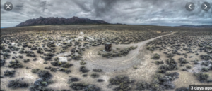
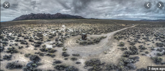
The results were devastating! The force of the explosion caused the ground in a radius of several miles to collapse, and created several deep fault lines that despite some “restoration” efforts by the AEC are still visible today. A steel pipe with a diameter of 7.4 feet had been drilled into the ground to place the bomb. Its top end was level with the surface before the test. After the explosion the top 9 feet of the pipe were exposed, due to the ground collapsing.
The blast also created a huge cylindrical underground cavity, a so-called nuclear rubble chimney. It is approximately 820 feet in diameter, and 2,460 feet in height. At its bottom lies over 500,000 metric tons of highly radioactive rubble, with radiation levels similar to the core of a nuclear reactor.
The completely unpredicted disastrous geological damage led to the cancellation of the entire project. The steel pipe was sealed with concrete, and all other sites that were being prepared for more, even more powerful tests were abandoned. The excavations can still be seen nearby. A bronze plaque reminding of the test was affixed to the top of the steel pipe, which now serves as a memorial, marking Ground Zero of the Project Faultless test.
The center of the blast, deep inside the ground, is contaminated with radiation for thousands of years. But it appears that the surface is relatively “clean”, and it is safe to visit the site. However, the plaque prohibits digging in the area, or even picking up material from the ground.
On the way, about 9.7 miles past the Warm Springs junction, you see a group of buildings and an airfield on the left side of US-6. This is Basecamp, built by the Atomic Energy Commission as base camp for the Central Nevada Test Area. After the project was cancelled the USAF took over Basecamp and extended the runway to its current size. Today it is used as an auxiliary airfield for the Air Force, including secret test flights out of TTR and Area 51.
Directions
From Rachel turn left onto Hwy 375 north. Follow it for about 59 miles. At the Warm Springs junction turn right onto US-6 east. After 25.4 miles you see a small sign pointing left to “Moores Station”. Turn left onto the well-maintained dirt road. After 12.2 miles you get to a 4-way intersection. Continue straight on the less developed dirt road, heading roughly west, for another 1.4 miles. Then you will see a mound of dirt directly ahead. The road splits here. Turn right, heading north. Then veer left, circling the north side of the mound. Another left turn onto a dirt track leading south brings you right to the monument shown below.
May require high clearance vehicle.
GPS Coordinates
| Rachel | N 37° 38.801′ | W115° 44.760′ | ||
| Queen City Summit | N37° 45.129′ | W115° 56.733′ | ||
| Warm Springs | N38° 11.447′ | W116° 22.218′ | ||
| Basecamp | N38° 18.705′ | W116° 16.807′ | ||
| Moores Station Turnoff | N38° 28.792′ | W116° 05.882′ | ||
| 4-way intersection | N38° 37.593′ | W116° 11.402′ | ||
| Project Faultless | N38° 38.058′ | W116° 12.920′ |
Related Links
- Project Faultless: Central Nevada’s Near Miss as an Atomic Proving Ground
- Basecamp – Photos and information from the Dreamland Resort web site